Road Maps of Ireland Taylor & Skinner 1777 Maps Nos 1-137
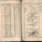
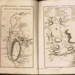
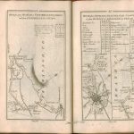
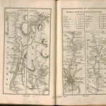
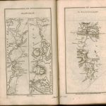
The first comprehensive road map of Ireland by Taylor & Skinner 1777. There are 288 pages of maps and 7 pages of indexes. The maps includes much topographical detail and the indexes show distances in Irish & English miles. The title page includes a vignette from the Battle of the Boyne. The dedication is to the Speaker of the House of Commons.
The L Brown Collection has also compiled a spreadsheet of the maps so that routes to and from individual towns may be easily identified.
(Image Full Screen plus Zoom and Pan controls are located in top right of Gallery when opened)
Click any image to open Gallery
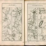
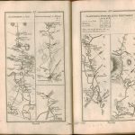
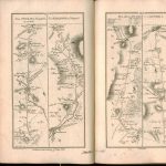
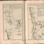
T & S Atlas-001-Dublin -Donaghdee
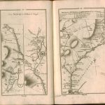
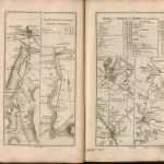
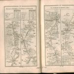
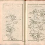
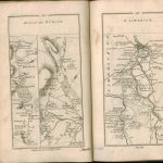
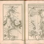
T & S Atlas-002-003-Dublin -Donaghdee
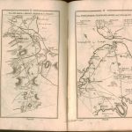
T & S Atlas-004-005-Dublin -Donaghdee
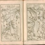
T & S Atlas-006-007-Dublin -Donaghdee+Dublin-Newry
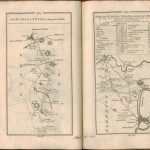
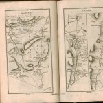
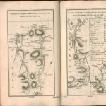
T & S Atlas-008-009-Dublin -Downpatrick+Portaferrry-Newtownardes
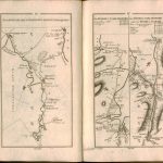
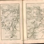
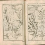
T & S Atlas-010-011-Portaferrry-Newtownardes+Dublin-Carlingford+Newry-Carlingford
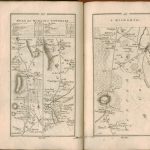
T & S Atlas-012-013-Newry-Clough+Dublin-Carrickfergus
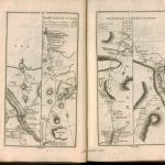
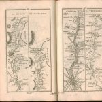
T & S Atlas-014-015-Dublin-Glenarm+Dublin-Coleraine
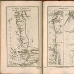
T & S Atlas-016-017-Dublin-Coleraine
T & S Atlas-018-019-Dublin-Coleraine
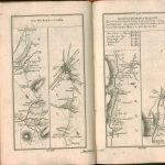
T & S Atlas-020-021-Dublin-Ballycastle-Glenarm-Newtownglens
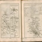
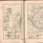
T & S Atlas-022-023-Newry-Market Hill-Stewartstown
T & S Atlas-024-025-Dublin-Coleraine+Portrush-Charlemont
T & S Atlas-026-027-Dublin-Coleraine
T & S Atlas-028-029-Dublin-Coleraine
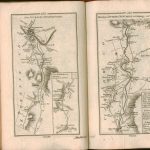
T & S Atlas-030-031-Dungiven-Coleraine+Dublin-Londonderry
T & S Atlas-032-033-Dublin-Newtown+Dublin-Londonderry
T & S Atlas-034-035-Dublin-Londonderry
T & S Atlas-036-037-Dublin-Londonderry
T & S Atlas-038-039-Dublin-Monaghan+Carrickmacross-Castleblaney+Dunleer-Mill of Louth
T & S Atlas-040-041-Dublin-Slane-Ardee+Drogheda-Duleek
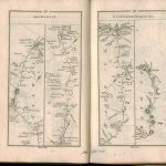
T & S Atlas-042-043-Dublin-Drogheda-Ballyshannon-Donegal
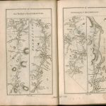
T & S Atlas-044-045-Dublin-Ballyshannnon+Donegal-Killybeggs
T & S Atlas-046-047-Dublin-Ballyshannnon+Donegal-Killybeggs
T & S Atlas-048-049-Dublin-Ballyshannnon+Donegal-Killybeggs
T & S Atlas-050-051-Dublin-Clones
T & S Atlas-052-053-Dublin-Clones-Enniskillen-Belturbet
T & S Atlas-054-055-Dublin-Enniskillen-Sligo
T & S Atlas-056-057-Dublin-Sligo-Granard
T & S Atlas-058-059-Dublin-Sligo
T & S Atlas-060-061-Dublin-Sligo-Longford
T & S Atlas-062-063-Dublin-Sligo-Longford
T & S Atlas-064-065-Dublin-Sligo-Longford
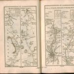
T & S Atlas-066-067-Dublin-KillalaRoscommon
T & S Atlas-068-069-Dublin-KillalaRoscommon-Boyle
T & S Atlas-070-071-Dublin-KillalaRoscommon-Boyle
T & S Atlas-072-073-Dublin-Castlebar
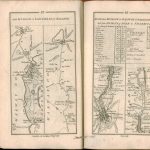
T & S Atlas-074-075-Dublin-Galway-Athlone
T & S Atlas-076-077-Dublin-Galway-Castlebar
T & S Atlas-078-079-Dublin-Castlebar
T & S Atlas-080-081-Dublin-Dunmore-Ahascragh-Loughrea
T & S Atlas-082-083-Dublin-Dunmore-Loughrea-Galway+Birr-Frankford
T & S Atlas-084-085-Dublin-Galway-Birr
T & S Atlas-086-087-Dublin-Galway-Birr
T & S Atlas-088-089-Dublin-Galway-Birr
T & S Atlas-090-091-Dublin-Galway+Dublin-Trim
T & S Atlas-092-093-Dublin-Ennis-Loughrea+Dublin-Kildare-Portarlington
T & S Atlas-094-095-Dublin-Limerick+Dublin-Kildare-Portarlington
T & S Atlas-096-097-Dublin-Limerick
T & S Atlas-098-099-Dublin-Limerick
T & S Atlas-100-101-Dublin-Ennis-Killaloe
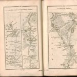
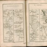
T & S Atlas-102-103-Dublin-Ennis+Dublin-Limerick-Tralee
T & S Atlas-104-105-Dublin-Limerick-Tralee
T & S Atlas-106-107-Dublin-Tralee-Dingle
T & S Atlas-108-109-Dublin-Dingle
T & S Atlas-110-111-Dublin-Tipperary-Kilworth
T & S Atlas-112-113-Dublin-Tipperary-Kilworth
T & S Atlas-114-115-Dublin-Kilkenny+Dublin-Clonmel
T & S Atlas-116-117-Dublin-Cork+Dublin-Carrick 0n Suir
T & S Atlas-118-119-Dublin-Cork+Dublin-Carrick 0n Suir
T & S Atlas-120-121-Dublin-Cork
T & S Atlas-122-123-Dublin-Cork-Mallow
T & S Atlas-124-125-Dublin-Mitchelstown+Midleton+Fermoy-Lismore
T & S Atlas-126-127-Dublin-Midleton-Cloyne+Dublin-Dungarvan-Youghal
T & S Atlas-128-129-Dublin-Youghal-Cork
T & S Atlas-130-131-Dublin-Youghal-Castlemartyr+Dublin-Waterford-Kilkenny
T & S Atlas-132-133-Dublin-Waterford+Dublin-New Ross